


Ficha 4 × 1
Date: 30/10/2012 to 31/10/2012
Saímos of: Salt Lake City, UT - USA
Total distance: 430 km
Where to sleep: We slept in Panguitch, city 40km from the entrance to a hotel parquet simple main avenue of the city, which is actually the highway. In other words, Simple hotel beira num Estrada.
Filled Tire : The combined track 3 corn mixture to Queens Garden + Navajo Loop Trail. A route is considered moderate, with gorgeous views all the time, which required constant stops to photograph.
Final destiny: Bryce National Park do, UT-USA
Travel time: 4,5 hours approx.
What we eat good: As we are only one day, the more different we ate was the tuna sandwich and chicken that took to track instead of tradiocinal loaf of bread with cheese and ham.
Tire murcho: The expulsion of the hotel early, em Panguitch. We arrived late in the day 30, tired, and was the last night of operation of the hotel before it closed for winter. We were asked to leave the room to 9:00 morning. In 5 people, and com 1 bathroom, everything was well run.
Path:We take as I-15 S.
After the warm welcome we had in metropolitan Salt Lake city, was time to leave for "wildlife" again. We went on 30 October Salt Lake City around 20:00 horas rumo ao Bryce Canyon, a national park, Utah ainda not. Was quase 1 morning hours when the thermometer marked +3the C when arriving at the hotel we had booked in Panguitch, city that offers some infrastructure and is 40 km from the park entrance. Divided em 2 casal beds and 1 one floor, slept like a rock until we agreed the 8:30 morning by the hotel's owner, since we arrived last night of operation before the hotel is closed for winter, logo do not give Halloween. Despite the cold that made overnight, the thermometer hit -2the C, The sky dawned clear, cloudless sun and tried to make us put our coats back on Tanajura. By sinal, park was the busiest in the United States who had visited so far, depending on the weather still pleasant, which was already southernmost.
The National Park Bryce Canyon is part of the Colorado plateau and is traditionally known for its unique geological structures, Call hodoos. These geological formations are the result of erosion caused by wind, water and ice, beyond the elevation of the plateau (the average altitude of the park is 2,400 m), which meant that most of the existing lakes disappear. Among the most ancient peoples who inhabited the region, those who left more traces were Paiutes, Native Americans who explored the region in search of food, not only hunting, but also through cultivation of vegetables. Were Paiutes who created the legend that hodoos were legendary people who had been turned into rocks. But it was from 1.850 researchers who began arriving, Mormons overwhelmingly, in search of prime land for agriculture and farm animal. One of the Mormons was sent the Scotsman Ebenezer Bryce, that through his carpentry skills would be important for the development of the region. And that was indeed what occurred. Together with his family, settled on the right bank of the amphitheater, creating a border park. Helped establish communities, developed a road to be able to carry firewood and wood and a canal to irrigate his crops and watering their animals. Eventually, other settlers began to call that area of Bryce Canyon, and hence arose the name of the park.

Hodoos vistos do Inspiration View

Bottom view of a hodoo
Reaching a national park in the United States is something that always impressed by the organization, cleaning and structure to receive visitors. After 10 minutes talking with rangers (guards / park guides), had all the infos we needed to take advantage of the one day that we would have in the park. Among the points we visited, the highlight was the trail 3 miles (4,8 km) duration, I had a harder it moderate and blended the Queens garden Trail and Navajo Loop Trail. The passage more "heavy", was a steep and winding hill, with curves forming a sort of zig-zag as we walked. Depending on the amount of amazing landscapes, stops for photography were constant, it made us take something around 3 hours to accomplish the route. It was necessary to take care of the dry land and the pebbles on the ground, that function as a banana peel, ready to take you to the ground. Called our attention the fact that in the middle “desert”, still exist condition that sprout trees, further coloring the landscape, that most of the time was composed of bluish sky, by green trees and red canyons of.

Lone Tree on the rocks

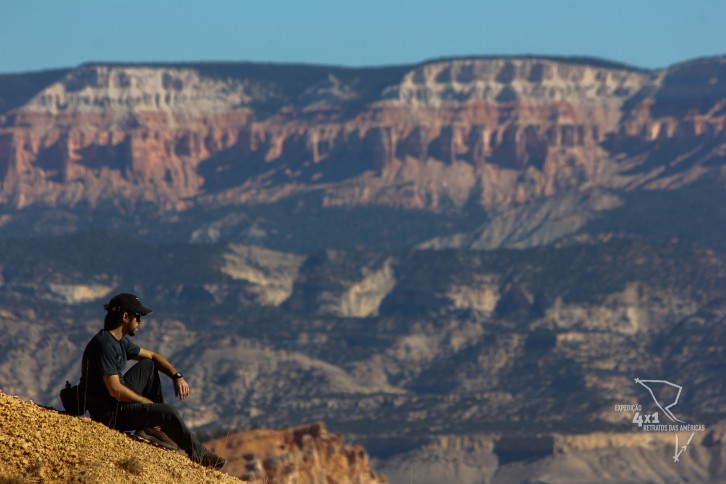
Expedition 4×1 no Inspiration View
According for more information about scattered throughout the park, There is an explanation for the coloration of formations. Originally, the ecru of the canyons is white, but with the iron particles deposited on the ground and oxidized with time were different colors and shades appearing as oranges, Yellow, Brown, red being the most striking feature. Moreover, the frequent and severe changes of temperature and incident light also affects the color over time. Moreover, The park also features several caves, that are the result of a concentration of water and snow q penetrate the innermost layer and areiosa and, to suffer pressure to be eliminated from the rocks, end up taking sand along.

Rocks in unstable equilibrium

Canyons

Hodoos trees and dividing the landscape
Already more to midafternoon, return to Tanajura, did a quick snack and headed for the scenic drive, A Estrada of 18 miles that cuts through the park and leads to the main viewpoints. As the road is two-way and the park is our left, we went to the last lookout and did all the stops on the way back. We passed several of them: Paria View, Rainbow and Yovimpa, Bryce Point, beyond Inspiration View, most of them impresionante. We stood there for almost 30 minutes admiring the scenery, feeling the wind blowing in our faces, a feeling as if time had stopped at that moment.

André hugging the wind

Ceu Azul and as rochas alaranjadas

End of the trail
After those relaxing moments, parted the scenic view and follow the road to our next destination. A quick pass and inspiring the "canyons" of reddish Bryce.
To access more photos, click here !
6 Comments
Boys… I agree with the words of John Roger, guys are excellent in teaching geography and history. It is a pleasure to read and learn in the information Posts. Congratulations and thank you.
A Merry Christmas to ALL!
And a YEAR 2013 WONDERFUL!!!
Health ! Prosperity ! Success !
Or Giselle!!! Thank you for the compliments and, mainly, the votes of Happy New Year!! We wish you much peace and lots of light and 2013 bring even more achievements and joys!! Beijos of all nós!
Incredible, this journey of you being in fact a rich class of geography and history for those who had no opportunity to travel and to enjoy that contact with nature. Nature is quite lavish in this matter of giving each region, a unique geological identity which influences the population adapting the residents in order to take full advantage in survival benefit. Not to mention of course, the eye candy to the point of making them literally stop in time to enjoy the beauty of the place. Congratulations guys!
Oi Rogério, we strive to spend a little bit of how much we have learned and experienced here! Glad you can feel that reading the posts!! Big hug!
S-U-P-E-R!!!!!
SUPERCALIFRAGIRIDEESPIRALIDOCI……
Geyza always surprising us with their creative comments,pt!! Muito legal!! XOXO